
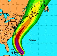
As of 11AM EDT Hurricane Earl is still tracking toward the outer banks/DC area as a category 3 and is still projected to turn in time to spare the region the full brunt. The NHC image shows why this is really a close call: presently, Earl is headed right at the middle of the east coast and some intensification is still possible. But it is forecast to begin curving more toward the north.  Forecasters sound confident it will turn, but the details of that expected curve could mean the difference between a storm that's barely noticeable and one that buzzes right up one of the most densely populated regions in the nation with almost surgical precision. A major hurricane plowing that stretch of coast could well rank among the most costly disasters in US history. Given the sheer number of homes and people in that swath, even a weakened or relatively distant Earl producing scattered and so-called minor damage could add up to big bucks and misery.
The President was briefed by FEMA head Craig Fugate a short time ago on the potential impacts of Hurricane Earl on the East Coast and New England. Emergency response teams are in place, some areas will be evacuated, and contingency evacuation plans for other regions are ready should the need arise. Residents in or near the outer banks of North Carlina and the greater DC metro area should complete preparations today. A Special Alert has been posted at North Carolina DOT. More info can be found at FEMA and GetReady.gov.
Update: Some noon models show a slight shift toward the west. Which is not the way we want it go.