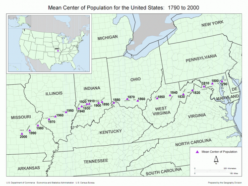
Data from the census bureau shows that we have been gradually moving west, as a nation.
The mean centre of US population is “the point at which an imaginary, flat, weightless and rigid map of the US would balance perfectly if weights of identical value were placed on it so that each weight represented the location of one person on the date of the census”, in the definition of the US Census Bureau itself.
That bureau has been holding censuses every decade since 1790; these censuses form the backdrop for this string of mean centres of population in the US. The map shows an ever westward shift of that centre, obviously in parallel with the westward expansion of the US and its citizenry.
Interestingly, the addition of Hawaii and Alaska to the Union (in 1959) didn’t cause as much of a shift as one might expect; it moved the mean centre only two miles south and ten miles west (1960).
The mean centre of population of the US has shifted thusly:
What will next year's census reveal?


