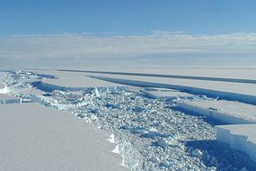
 The Wilkins Ice Shelf is a shelf of ice in the Antarctica, one of ten on the Antarctic peninsula.
Due to global warming, it has been breaking up for a couple of decades. In the 1990s it measured 6,200 square miles. Now it is thought to be at least half that size.
Scientists were still unsure how long the retreat of the ice shelf would be.
But events over the past couple of days have led them to conclude that the break up will be sooner than expected.
This is because an ice bridge over 60 miles long — but at its narrowest just 1/3 of a mile wide — kept the Wilkins shelf intact to the Antarctic. But something happened to that ice bridge. It was there two days ago — now it is a mass of shattered ices and bergs (shown above right).
This means that the Wilkins Ice Shelf itself — an area the size of Connecticut — could break off from the Antarctic soon. Scientists hope the shelf will remain in its current position for the next few months, since the Antarctic summer is coming to a close. But once the Antarctic winter ends and temperatures rise again, the Wilkins Ice Shelf could float away from the rest of the continent and breakup.
The 17-frame animated gif below shows the breakup from satellite imagery, in sequence from March 22 to today.
The island visible in the upper left of the image is Charcot Island, and Latady Island at the bottom. The Wilkins Ice Shelf is connected to these by an ice bridge.
The 60+ mile ice bridge is visible as a narrow strip near the center of the image (I've added a blue circle to the area on the first frame –focus your eyes there).
Over the course of the photos, you can see ice bridge turn into something resembling shattered glass by the last image (taken earlier today). You can also see breakup of the ice bridge to the "southeast" of where I drew the blue circle.
Global warming a hoax?


